

Handy GPS MOD APK , PAID/Patched
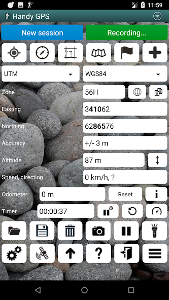
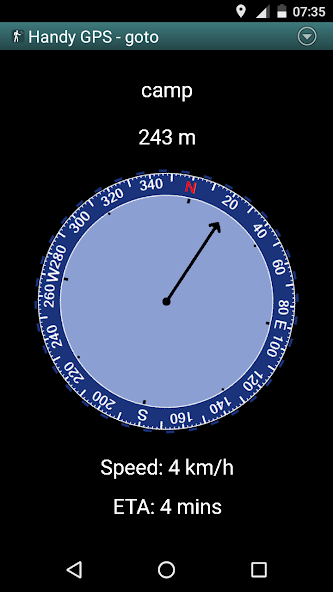
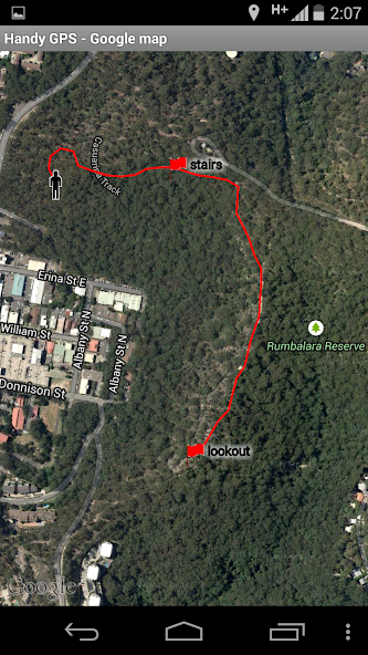
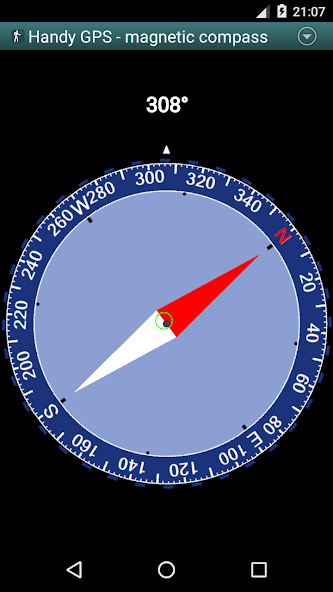
The perfect companion for your next outdoor adventure. Seek, find, record and return home with Handy GPS.This app is a powerful navigation tool designed for outdoors sports like hiking, bushwalking, tramping, mountain biking, kayaking, boating, horse trail riding, geocaching. Its also useful for surveying, mining, archaeology, and forestry applications. Its simple to use and works even in the remotest back country since it doesn't require network connectivity. It allows you to work in UTM or lat/lon coordinates so you can even use it with your paper maps.NOTE: Allow the app to always use GPS, and turn off battery optimisation for the app to reliably record tracklogs when the phone screen is off.BASE FEATURES:* Shows your current coordinates, altitude, speed, direction of travel, and distance travelled in metric, imperial/US, or nautical units.* Can store your current location as a waypoint, and record a track log to show where you've been on a map.* Data can be imported from and exported to KML and GPX files.* Allows manual entry of waypoints in UTM, MGRS and lat/lon coords.* Can guide you to a waypoint using the "Goto" screen, and optionally sound an alert when when you're getting close.* Has a compass page which works on devices with magnetic field sensors.* Automatically computes the local geoid offset to improve altitude accuracy* Supports the world-wide WGS84 datum along with the common Australian datums and map grids (AGD66, AGD84, AMG, GDA94, and MGA). You can also use WGS84 for NAD83 maps in the US.* Shows GPS satellite locations and signal strengths graphically.* Can display simple or MGRS grid references.* Can compute waypoint-to-waypoint distance and direction.* Includes an optional timer line to record walk duration and compute your average speed.* Thoroughly tested by the developer on many off-track walksEXTRA FEATURES IN THIS VERSION:* No ads, no subscriptions, and nothing more to pay after your initial purchase.* Unlimited number of waypoints and track log points.* Email or SMS your location to a friend as a clickable map link.* Email your waypoints and tracklogs as KML or GPX file.* Supports common datums such as NAD83 (US), OSGB36 (UK), NZTM2000 (NZ), SAD69 (South America) and ED50 (Europe), and you can configure your own custom datums, including local grid systems.* UK grid refs with two letter prefixes can be shown if OSGB datum selected.* Elevation profile.* GPS averaging mode.* Take photos and record voice memos, geo-located with KML files for easy viewing on a PC.* Geo-tag photos, and/or have the coordinates and bearing "burnt" into the image.* Sun rise and set times.* Export data to CSV file.* Create waypoint by triangulation, or projecting using an entered distance and bearing.* Compute length, area, and elevation change for tracklog.* Offline map support by downloading tiles from map tile servers, importing pre-prepared base maps from zip files, or registering your own map images.* Compute calories.* Optional background image.* Optional location sharing on web.* Spoken distance and direction guidance on goto page.PERMISSIONS: (1) GPS, to show your location, (2) Network access, to load maps, (3) SD card access, to load and store waypoints, (4) Camera access, for taking pics, (5) Prevent phone from sleeping, so proximity alarm works, (6) Control flashlight, to allow flashlight use, (7) Record audio for voice memos.DISCLAIMER: You use this app at your own risk. The developer accepts no responsibility for you getting lost or injured as a result of using this app. Batteries in mobile devices can go flat. For extended and remote hikes, a battery bank and an alternative method of navigation such as a paper map and compass are recommended for safety.
Handy GPS Introduction
Handy GPS As a very popular navigation app recently, it has attracted a large number of users who love navigation all over the world. If you want to download this app, moddroid is your best choice. moddroid not only provides you with the latest version of Handy GPS for free, but also provides PAID/Patched mods for free to help you unlock all the features of the app for free. moddroid promises that all Handy GPS mods will not charge users any fees, and are 100% safe, available, and free to install. Just download the moddroid client, you can download and install Handy GPS with one click. What are you waiting for, download moddroid now!
Convenient Features
Handy GPS As a popular navigation application, its powerful functions have attracted a large number of users. Compared with traditional navigation applications, Handy GPS provides a richer experience and more powerful functions. You only need to Download and installHandy GPS, you can easily experience all the functions, and it is completely free! In addition, moddroid also supports the navigation application for fans to exchange experiences with each other, share the happiness they encounter in the application, what are you waiting for, come and download it now
Unique Mod
moddroid not only provides originalHandy GPS completely free, but also attaches the mod version, providing you with PAID/Patched functions for free, you can experience the highest level of Handy GPS with the most complete functionality. Moreover, all mods have been manually authenticated by moddroid, it is 100% free and available. Now, you only need to download moddroid to the client, you can download and install the PAID/Patched mod version Handy GPS with one click, and then enjoy The convenience brought by Handy GPS!
Download Now
Just click the download button to install the moddroid APP, you can directly download the free mod version Handy GPS in the moddroid installation package with one click, and there are more free popular mod apps waiting for you to play, what are you waiting for, download it now!

